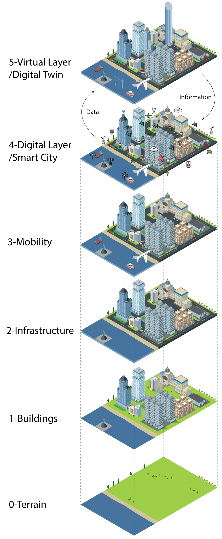
Step 1: Laying the Groundwork with Terrain Data
The foundation of any digital twin smart city is the terrain layer. This involves collecting and integrating detailed geographical information about the city’s landscape. Key elements include identifying areas of offshore terrain, rivers, canals, gradients, hills, and different soil types. This layer is crucial for understanding the environmental challenges and opportunities the city may face, such as flooding, landslides, or agricultural prospects. A comprehensive soil map can be instrumental in integrating this data into the digital twin model.
Step 2: Building the City with Accurate Models
Once the terrain is mapped out, the next step is to add the city’s buildings to the digital twin. This involves using highly accurate Building Information Modeling (BIM) and 3D building data, potentially generated through stereoscopic aerial photography. This layer brings the city's physical structures to life in the digital model, allowing for detailed analysis and planning regarding space utilization, building efficiency, and urban aesthetics.
Step 3: Integrating Infrastructure
Infrastructure is the backbone of any city, and in a digital twin, it comprises the third layer. This includes all the essential services and facilities such as roads, power supplies, water systems, and telecommunications networks. Data for this layer can be sourced from platforms like OpenStreetMap or through detailed 3D mapping processes. Accurate infrastructure modeling is vital for simulating the operational aspects of the city and planning for sustainable growth and disaster resilience.
Step 4: Enhancing Mobility
The mobility layer adds dynamics to the static models of buildings and infrastructure. It incorporates the various modes of transportation and the movement patterns of people and goods. Urban mobility can be modeled in detail, including pedestrian flow, vehicle traffic, and public transportation systems. This layer is key to optimizing traffic, reducing congestion, and improving the overall accessibility of the city.
Step 5: Implementing the Digital Layer
This layer represents the fusion of physical and digital realms within the cityscape. It involves deploying IoT sensors and devices throughout the city to collect real-time data on traffic, utilities, public services, and environmental conditions. This data is crucial for the continuous updating and accuracy of the digital twin model. It enables city managers to monitor, analyze, and respond to urban dynamics effectively.
Step 6: Creating the Virtual Layer
The final step is the development of the virtual layer or the actual digital twin itself. This layer uses the data collected from the smart city infrastructure to simulate different aspects of urban life and infrastructure. It allows for testing and optimizing scenarios like renewable energy deployment, building construction, and traffic management. The virtual layer is where theoretical planning meets practical application, providing a platform for decision-makers to visualize the impacts of their choices before implementing them in the real world.